
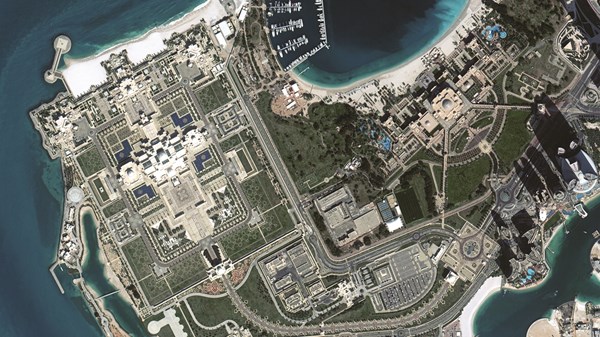
Dr. Saeed Al Mansoori, Director of the Remote Sensing Department at the Mohammed bin Rashid Space Centre, has highlighted a significant transformation in the centre’s capabilities in satellite image analysis over recent years. This development is primarily supported by advancements in the national satellite system and data analysis technologies.
Enhancements through New Satellites
In an interview with “Al-Ittihad,” Dr. Al Mansoori explained that the launch of the “Mohammed bin Zayed Satellite” has significantly improved image resolution, increasing the volume of images produced tenfold compared to previous generations. With a processing time of less than two hours for data delivery, this enhancement enables faster governmental response times to various needs.
Furthermore, the debut of “Etehad Sat,” the centre’s first radar satellite, has bolstered remote sensing capabilities by providing high-resolution images in various weather conditions, both day and night. This technology complements existing optical satellites, offering more comprehensive and accurate data.
Support for Decision-Making
Dr. Al Mansoori pointed out that national satellite data—including “Mohammed bin Zayed Sat,” “Etehad Sat,” and “Khalifa Sat”—is pivotal in urban planning, infrastructure management, environmental monitoring, and natural resource management. This data provides crucial insights that aid decision-makers across various sectors.
A Growing Body of Work
Over the past three years, the centre has completed more than 250 analytical studies and reports for governmental and private entities. In 2025 alone, over 66 analytical studies were conducted on global crisis management, evaluating the impacts of earthquakes, floods, landslides, fires, and hurricanes, while also supporting emergency relief operations and updating maps of affected regions.
In addition, more than 25 focused environmental studies have monitored vegetation cover, tracked environmental changes, analysed land usage, and identified the effects of climate change and desertification, contributing to sustainability efforts and natural resource management.
Integrating AI in Image Analysis
The integration of artificial intelligence (AI) and machine learning has become fundamental to the centre’s satellite image analysis framework. These technologies have reduced data processing time from days to hours, enabling specialised reports to be issued within 12 to 24 hours after disasters occur.
Moreover, AI has enhanced the precision of the results by automating change detection processes and improving classification quality and geographical indicator extraction, thereby boosting data reliability and facilitating timely decision-making.
A Comprehensive Remote Sensing System
The centre is continuously developing a comprehensive remote sensing and geospatial data analysis system, which features an improved platform for geographic data analysis powered by AI. This platform offers real-time data and predictive insights to support decision-makers.
Applications within this platform include monitoring earthquakes and emergencies, analysing land usage, tracking land and sea temperatures, predicting fog and winds, observing coastal changes, and overseeing vegetation cover, in addition to infrastructure monitoring and urban expansion.
Enhancing National Capabilities
Dr. Al Mansoori emphasised that several vital sectors in the UAE currently benefit from satellite image analysis services, including urban planning, infrastructure project management, environmental change monitoring, and the management of natural and water resources. These insights are instrumental in improving planning efficiency and achieving sustainable development goals.
The centre is dedicated to building national competencies in remote sensing, geographic information systems, and satellite data analysis. Initiatives include supporting the Emirates Society for Geographic Information and Remote Sensing, alongside implementing specialised training programmes and workshops for students, researchers, engineers, and employees. In 2025, over 430 trainees benefitted from training focused on satellite image analysis, remote sensing, geographic information systems, and AI applications, bridging theoretical knowledge with practical application using real satellite data.
Future Prospects
Looking ahead, Dr. Al Mansoori expressed optimism about the future of the satellite image analysis sector in the UAE amidst rapid advancements in satellite, AI, and big data technologies. He anticipates that space data will become increasingly essential in supporting planning, decision-making, and the development of smart solutions.
He further noted that these technologies will play a crucial role in achieving sustainable development objectives, supporting food and water security, managing natural resources, monitoring the environment, and building smarter, more sustainable cities. This will also enhance the knowledge-based economy by transforming space data into economic and informative value that bolsters various public and private sectors, establishing the UAE’s position as a global leader in space science and remote sensing.